Explore over 500,000 Images in my personal collection
Cloud Streets, Climate Change, Bering Sea
Code Number:
UPDD01_007
Title:
Cloud Streets, Climate Change, Bering Sea
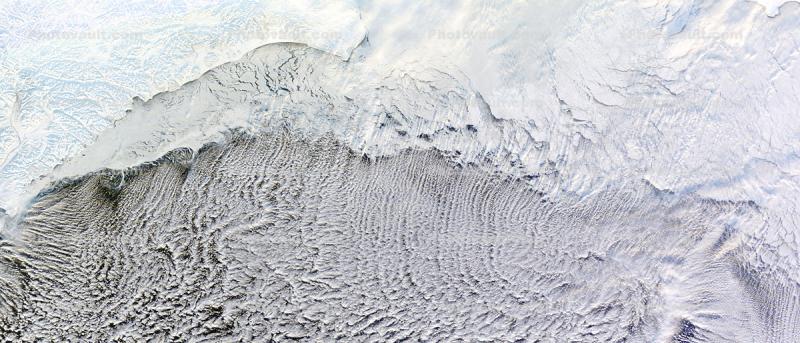
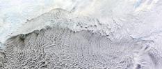
The Moderate Resolution Imaging Spectroradiometer (MODIS) on NASA?s Terra satellite captured this natural-color image on January 4, 2012.
Cloud streets depend on ice. These cloud formations developed over the Bering Sea in part because of the snow and ice blanketing the land and the sea ice clinging to the coast. Air blowing over ice and then warmer ocean water can lead to the development of parallel cylinders of spinning air. On the upper edge of these cylinders of rising air, small clouds form. Along the downward side (descending air), skies are clear. The resulting cloud formations resemble streets.
This image shows that some of the clouds begin over the sea ice, but most hover over the open ocean. These streets are not perfectly straight, curving to the east and west after passing over the sea ice. By lining up along the prevailing wind direction, the tiny clouds indicate the wind patterns around the time of formation. Credit: NASA images courtesy LANCE/EOSDIS MODIS Rapid Response Team at NASA GSFC. Caption by Michon Scott.
Keywords:
Universe, Planets, Earth, Data, Aerials as seen from Space, Resource, Map
Image by:
NASA
Cloud Streets, Climate Change, Bering Sea
BUY IMAGE(S) NOW
Code Number:
UPDD01_007
Title:
Cloud Streets, Climate Change, Bering Sea
The Moderate Resolution Imaging Spectroradiometer (MODIS) on NASA?s Terra satellite captured this natural-color image on January 4, 2012.
Cloud streets depend on ice. These cloud formations developed over the Bering Sea in part because of the snow and ice blanketing the land and the sea ice clinging to the coast. Air blowing over ice and then warmer ocean water can lead to the development of parallel cylinders of spinning air. On the upper edge of these cylinders of rising air, small clouds form. Along the downward side (descending air), skies are clear. The resulting cloud formations resemble streets.
This image shows that some of the clouds begin over the sea ice, but most hover over the open ocean. These streets are not perfectly straight, curving to the east and west after passing over the sea ice. By lining up along the prevailing wind direction, the tiny clouds indicate the wind patterns around the time of formation. Credit: NASA images courtesy LANCE/EOSDIS MODIS Rapid Response Team at NASA GSFC. Caption by Michon Scott.
Keywords:
Universe, Planets, Earth, Data, Aerials as seen from Space, Resource, Map
Image by:
NASA
Caption Disclaimer

Royalty Free: Calculate Price

418 x 179 pixels This image size immediately available after purchase 1 PhotoPoints $3.00
1200 x 514 pixels This image size immediately available after purchase 1 PhotoPoints $3.00
2350 x 1007 pixels This image size immediately available after purchase 6 PhotoPoints $18.00
5400 x 2313 pixels This image size available in 3 hours after purchase 15 PhotoPoints $45.00
Ultra Hi for larger output size, please call customer service 415-720-9928
Climate ChangeHimalayas, Bangladesh, Ganges River, India, China, Climate Change, Bay of BengalBay of Bengal, BangladeshPine Beetle Infestation in British ColumbiaCloud Streets, Climate Change, Bering SeaMystery Plankton Bloom in the Bering Sea, June 6, 2001, Climate ChangeMystery Plankton Bloom in the Bering Sea, June 6, 2001Sea Ice, Bering Sea, 2012, Climate ChangeSnow Clouds Stream off Lake Michigan, Canada, USA, Winter, Climate ChangeCentral Sahara Desert: A Wet Past, Algeria, Libya, rock massifs, sand dunes, dendritic structuresTyphoon Chaba Colorado RiverDesertCotopaxi Volcano, Ecuador, stratovolcano
Go to lightbox