Explore over 500,000 Images in my personal collection
real images | real history | no AI

|
|
- Code Number:
- UPVV01P02_07
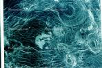
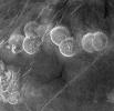
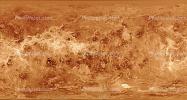
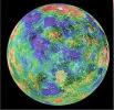
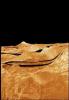
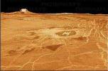
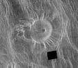
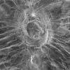
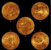
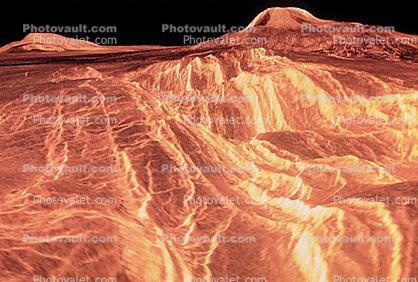
- This image is a composite of the complete radar image collection obtained by the Magellan mission. The Magellan spacecraft was launched aboard space shuttle Atlantis in May 1989 and began mapping the surface of Venus in September 1990. The spacecraft continued to orbit Venus for four years, returning high- resolution images, altimetry, thermal emissions and gravity maps of 98 percent of the surface. Magellan spacecraft operations ended on October 12, 1994, when the radio contact was lost with the spacecraft during its controlled descent into the deeper portions of the Venusian atmosphere. Venus is displayed in this simple cylindrical map of the planet's surface. The right and left edges of the image are at 240 degrees east longitude. The top and bottom of the image are at 90 degrees north latitude and 90 degrees south latitude, respectively. Magellan synthetic aperture radar mosaics are mapped onto a rectangular latitude- longitude grid to create this image. Data gaps are filled with Pioneer-Venus Orbiter altimetric data, or a constant mid-range value. Simulated color is used to enhance small-scale structure. The simulated hues are based on color images recorded by the Soviet Venera 13 and 14 spacecraft. At the top, left of center, the bright region is Maxwell Montes, the highest mountain range on Venus. Extending along the equator to the right of center is Aphrodite Terra, a large highland region on Venus. The scattered dark patches in this image are halos surrounding some of the younger impact craters. This global data set reveals a number of craters consistent with an average Venus surface age of 300 million to 500 million years. The image was produced by the Solar System Visualization Project and the Magellan science team at the Jet Propulsion Laboratory'?s Multimission Image Processing Laboratory.
- Keywords:
- Image by:
- NASA
- Caption Disclaimer
Royalty Free: Calculate Price