Explore over 500,000 Images in my personal collection
real images | real history | no AI

|
|
- Code Number:
- FWPV01P04_11
- Title:
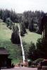
- Moffat-Water-Tunnel, Colorado
- This single track railroad runs directly under the Continental Divide. It is 80 km (50 miles) west of Denver, Colorado. It also carries the water tunnel that supplies a portion of Denver area water. The East Portal is about 16 km (10 miles) west of the town of Rollinsville, Colorado at Coordinates: 39?54 08 N 105?38 46 W / 39.90235?N 105.6461?W / 39.90235; -105.6461. The West Portal is near the Winter Park Resort ski area at 39?53 15 N 105?45 41 W / 39.887434?N 105.761347?W / 39.887434.
Height: 7.3 m (24 feet)
Width: 5.5 m (18 feet)
Length: 10.0 km (6.2 miles)
Highest point: 2,816 m (9,239 feet) above sea level
Construction: 1923
Finished: 1927
First train: 1928 - Keywords:
- Image by:
- Wernher Krutein
- Caption Disclaimer
Royalty Free: Calculate Price