Animals
Cities
Disasters
Entertainment
Food
Government
Health
Industry
Insects
Military
Nature
People
Sports
Technology
Universe
Vehicles
Explore over 500,000 Images in my personal collection
real images | real history | no AI
|
|
- Code Number:
- CJEV01P06_01
- Title:
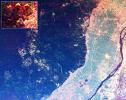
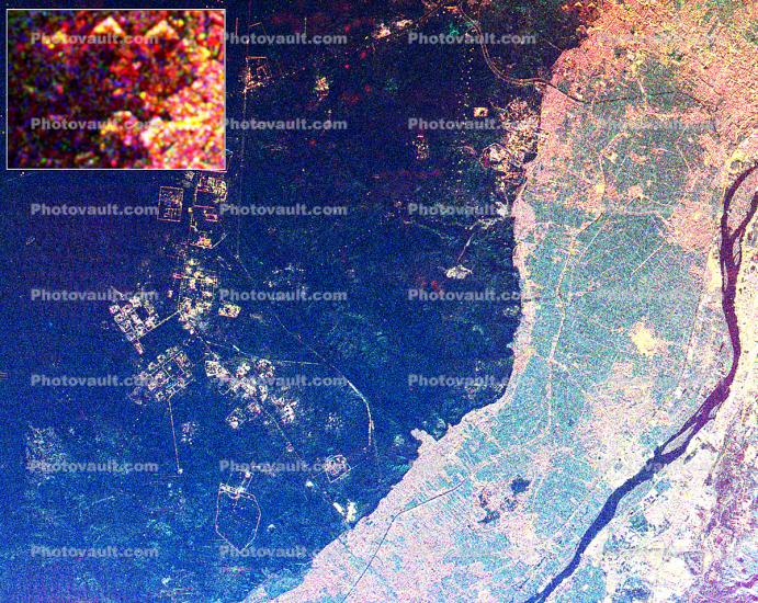
- This radar image shows the area west of the Nile River near Cairo, Egypt
- The Nile River is the dark band along the right side of the image and it flows approimately due North from the bottom to the right. The boundary between dense urbanization and the desert can be clearly seen between the bright and dark areas in the center of the image. This boundary represents the approimate etent of yearly Nile flooding which played an important part in determining where people lived in ancient Egypt. This land usage pattern persists to this day.
The pyramids at Giza appear as three bright triangles aligned with the image top just at the boundary of the urbanized area. They are also shown enlarged in the inset bo in the top left of the image. The Great Pyramid of Khufu (Cheops in Greek) is the northern most of the three Giza pyramids. The side-looking radar illuminates the scene from the top, the two sides of the pyramids facing the radar reflect most of the energy back to the antenna and appear radar bright; the two sides away from the radar reflect less energy back and appear dark Two additional pyramids can be seen left of center in the lower portion of the image.
The modern development in the desert on the left side of the image is the Sith of October City, an area of factories and residences started by Anwar Sadat to relieve urban crowding. The image was taken on April 19, 1994 by the Spaceborne Imaging Radar-C/X-Band Synthetic Aperture Radar (SIR-C/X-SAR) aboard the shuttle Endeavor. SIR-C/X-SAR, a joint mission of the German, Italian and the United States space agencies, is part of NASA's Mission to Planet Earth.
The image is centered on latitude 29.72 degrees North latitude and 30.83 degrees East longitude. The area shown is approimately 20 kilometers by 30 kilometers. The colors in the image are assigned to different frequencies and polarizations of the radar as follows: red is L-band horizontally transmitted, horizontally received, green is C-band horizontally transmitted, horizontally received, blue is C-band horizontally transmitted, vertically received. - Keywords:
- Image by:
- Manfred Krutein
- Caption Disclaimer
Royalty Free: Calculate Price