Animals
Cities
Disasters
Entertainment
Food
Government
Health
Industry
Insects
Military
Nature
People
Sports
Technology
Universe
Vehicles
Explore over 500,000 Images in my personal collection
real images | real history | no AI
|
|
- Code Number:
- CGKV01P09_14
- Title:
- Star City
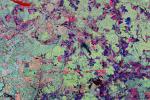
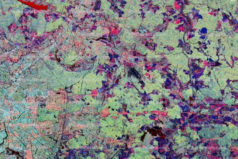
- This radar image shows the Star City cosmonaut training center, east of Moscow, Russia. Four American astronauts trained here for the long-duration flights aboard the Russian Mir space station. These joint flights are giving NASA and the Russian Space Agency eperience necessary for the construction of the international Alpha space station, beginning in late 1999. This image was acquired by the Spaceborne Imaging Radar-C/X-band Synthetic Aperture Radar (SIR-C/X-SAR), on its 62nd orbit on October 3, 1994. This Star City image is centered at 55.55 degrees north latitude and 38.0 degrees east longitude.
The area shown is approimately 32 kilometers by 49 kilometers (20 miles by 30 miles). North is to the top in this image. The radar illumination is from the top of the image. The image was produced using three channels of SIR-C radar data: red indicates L-band (23 cm wavelength, horizontally transmitted and received); green indicates L-band (horizontally transmitted and vertically received); blue indicates C-band (6 cm wavelength, horizontally transmitted and vertically received). In general, dark pink areas are agricultural; pink and light blue areas are urban communities; black areas represent lakes and rivers; dark blue areas are cleared forest; and light green areas are forested. The prominent black runways just right of center are Shchelkovo Airfield, about 4 km long. The tetured pale blue-green area east and southeast of Shchelkovo Airfield is forest. Just east of the runways is a thin railroad line running southeast; the Star City compound lies just east of the small bend in the rail line.
Star City contains the living quarters and training facilities for Russian cosmonauts and their families. Moscow's inner loop road is visible at the lower left edge of the image. The Kremlin is just off the left edge, on the banks of the meandering Moskva River. The Klyazma River snakes to the southeast from the reservoir in the upper left (shown in bright red), passing just east of Star City and flowing off the lower right edge of the image. The dark blue band of the Vorya River runs north-south in the upper right quadrant, east of Star City. SIR-C/X-SAR radar images are being compared with data from the Russian radar satellite Almaz to evaluate the usefulness of a permanent orbital radar platform in monitoring Earths environment and ecology. - Keywords:
- Caption Disclaimer
Royalty Free: Calculate Price